Google Maps adds one million public transit stop schedules
Google has revealed the latest update to its Maps service, collaborating with hundreds of transit authorities around the world to make a comprehensive resource for millions of riders to find out which bus, train, subway or tram can take them to their next destination.
Today, Google Maps has public transportation schedules for more than one million transit stops worldwide, in nearly 500 cities including New York, London, Tokyo and Sydney.
“Public transportation information is especially useful when it is in the palm of your hand,” said Christopher Van Der Westhuizen, software engineer, Google Maps.
“Today we are releasing an update to the Google Maps for Android app (version 6.10) which makes this transit information even more useful.
“We have made some changes to the Transit Lines layer, so that you can select a specific mode of public transportation (train, bus, tram or subway) to display on the mobile map, hiding the other modes.
“This is helpful in areas where there is a tight concentration of several types of public transit.”
Google confirmed it has been working on the project around the world since 2005.
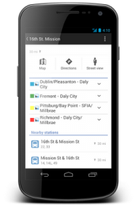
“We’ve also updated the layout of station pages to be more useful. Open it by tapping on the name of the station on your mobile map,” Van Der Westhuizen said in a blog posted earlier.
Updated station pages show you departure times, lines serving the station and the distance to nearby stations.
In addition to these new transit features, Google has updated the region highlighting, My Places and Location History displays in Google Maps for Android.
Now, whenever searching for a city or postal code, the borders of that region are highlighted.
Under My Places users will see Google has added new tabs, which will help access all the information from a single place; from saved maps for use offline to starred places and Custom Maps created on the desktop.