Google Maps finds new partner in VisitFlorida
 The project will take four months to complete
 A team from VisitFlorida has begun a four-month odyssey to capture stunning images of the Sunshine State’s 825 miles of beaches using Google’s Street View Trekker technology.
These 360-degree images will be integrated into Google Maps, enabling potential visitors from around the globe to experience interactive views of Florida’s world-renowned beaches before they ever leave home.
Governor Rick Scott said: “This technology from Google will allow anyone in the world to see how vast and beautiful Florida’s beaches are, which will create more opportunities for tourism.
“While this technology will better connect the world to Florida’s beaches, there’s no substitute for the real thing.
“For anyone who’s interested in Florida’s beaches, this will ultimately be a great tool so they can better plan for their next trip to the Sunshine State.”
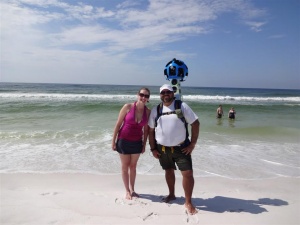
The imagery will be collected by two-person teams (trained by Google Maps experts) who will use the Street View Trekker and walk roughly 50 miles of beaches each week.
The Trekker is a wearable backpack with a camera system on top.
Its 15 lenses are angled in different directions to capture a complete picture of a location, and the images are then stitched together into 360-degree panoramic views.
The completed imagery, scheduled for release next year, will enable viewers to digitally explore Florida shorelines step by step.
“VisitFlorida loves to engage with our visitors through interactive storytelling, and there’s no better way to tell the Sunshine State story than through this incredible partnership opportunity with the world’s largest search engine,” said Paul Phipps, chief marketing officer, VisitFlorida.
“I’ve seen some of the early footage that’s being shot and it’s absolutely breathtaking.
“I can hardly wait for everyone to see the final images.”